
AUCTIONS (2)
 | Fine quality Ohi Ware Macha bowl by Yoshio Iwamura |
 | Antique Tibetan painted wood image of Green Tara Bodhisattva |
 | SUISEKI OF FERTILITY |
 | 1st ED ~ Inspiring Reform ~Boston's Arts & Crafts Movement HC/DJ |
SALE PRICED
 | Young People's Illustrated Bible History...1879 Engravings+Maps |


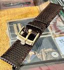
Watch Company
$150.00
$150.00
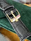
Rolex 16mm Yellow Plate Logo Buckle 19mm TOBACCO Genuine Lizard Strap. We fitted this Rolex plated buckle on the highest grade 19mm Lizard available.
The strap was hand made in Italy and is of the finest quality. THIS IS A FINE COLLECTIBLE. INVEST IN HARD ASSETS, DON'T INVEST IN THE STOCK MARKET. BUY SOMETHING PROVEN IN TIME.
We have been selling vintage watches on E-Bay since 1998 as watchco1973 with 14,500 feed backs, 100% positive. You can buy from us with confidence...
We have been selling vintage watches on E-Bay since 1998 as watchco1973 with 14,500 feed backs, 100% positive. You can buy from us with confidence...
Jon Berg Fine Art and More
$150.00
$150.00
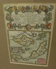
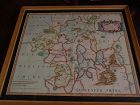
A very nice example of the 1753 map "The Smaller Islands in the British Ocean", published by T. Bowles, London, engraved by Emmanuel Owen, text by John Owen, the map featuring the Isle of Wight, Scilly Islands in the far southwest, the Channel Islands of Guernsey, Jersey, and Alderney, as well as Farne Island and Holy Island. At top is given the mile marker landmarks on the road from London to Southampton. Beautiful unusually good quality hand-coloring and condition is excellent...
All Items : Traditional Collectibles : Ephemera : Photographs : Special Interest : Pre 1900
item #1325642
Kensington House Antiques
$160.00
$160.00
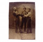
An interesting tintype photograph depicting two men boxing while a referee looks on. The style of hat worn by the referee suggests the photograph dates to the 1880’s.
Dimensions: 2-3/8” x 3-7/16”. Condition: extremely minor surface wear (mostly in background areas), light waviness in the middle of the plate.
David Anthony
$175.00
$175.00
Hardcover. Condition: Good. 2nd Edition. Bound in polished leather, printed on laid paper, gilt tooling on spine, all leather spine labels intact, all covers attached, binding and hinges secure. Previous ownership: armorial bookplate for Thomas Taylor, County Devon parish Denbury...
Jon Berg Fine Art and More
$175.00
$175.00
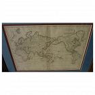
Early 19th century map of the world, in Mercator projection, the Pacific Ocean at center, titled at upper right "Mappemonde sur la Projection de Mercator", measuring 10" by 14 1/2" inside the double mats, and 16" by 21" as nicely framed. The map might date to about the 1820's. The United States is shown as "Etats Unis". There are numerous picturesque early geographic names like "Is. Sandwich/Owhyhee", "Othahiti", "Nouvelle Hollande" for Australia, The map is printed on old style paper...
Jon Berg Fine Art and More
$175.00
$175.00
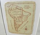
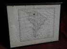
A charming completely hand-drawn map of the South American continent, likely created by a school child at a time when geography was taught to youngsters, measuring 8 1/2" by 6 1/2" (19" by 15 1/2" in black strip modern framing). The age looks to be 19th century. The creator used a red-brown ink, and pencil underlying in some places. Note the cartouche at lower right, and the quaint term "Amazonia" and "Brasil" spelling. The map has been mounted in recent times...
All Items : Traditional Collectibles : Ephemera : Autographs : Political : Pre 1970
item #1423072
(stock #JB04485)
Jon Berg Fine Art and More
$175.00
$175.00
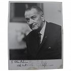
Original, HAND SIGNED AND INSCRIBED black and white photo from 1965, of the 36th president of the United States, LYNDON BAINES JOHNSON (1908-1973). Johnson became president upon the assassination of John F. Kennedy in Dallas in 1963. He was elected to the office on his own in 1964. A Democrat, he oversaw the ramping up of the war in Vietnam and landmark social legislation. The photo is inscribed to one Ellen Oshim. The writing reads "To Ellen Oshim/with best wishes. / Lyndon B Johnson"...
All Items : Traditional Collectibles : Ephemera : Photographs : Special Interest : Pre 2000
item #1491221
(stock #VW1858)
Watch Company
$175.00
$175.00
Rolex 16mm Yellow Gold Plate Buckle 20mm Black Genuine Crocodile Strap. The strap is a new genuine stitched and padded very high grade "Hand Made in Italy". The Rolex buckle is plated (not solid gold) but is very secure and looks very nice! THIS IS A FINE COLLECTIBLE. INVEST IN HARD ASSETS, DON'T INVEST IN THE STOCK MARKET. BUY SOMETHING PROVEN IN TIME.
We have been selling vintage watches on E-Bay since 1998 as watchco1973 with 13,500 feed backs, 100% positive...
We have been selling vintage watches on E-Bay since 1998 as watchco1973 with 13,500 feed backs, 100% positive...
All Items : Traditional Collectibles : Ephemera : Photographs : Pre 1900
item #1376134
(stock #TBD00244)
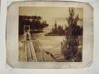
An oversize albumen photograph of a carriage on a narrow bridge with the rising spray from Niagara Falls visible in the distance. I am reasonably confident that this a bridge connecting Goat Island to the river bank on the American side or possibly a bridge connecting Goat Island to one of the Three Sisters...
Jon Berg Fine Art and More
$195.00
$195.00
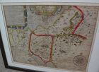
This is a very detailed map of Worcestershire in western England, first engraved by noted London map maker Robert Morden in 1695 for Camden's Britannia, and issued in several later editions in the early years of the 18th century. The map measures 14 1/4" by 16 5/8" inside the mat (17" by 19" as framed). Like most of its type it has been hand colored at a later date. The condition is good, with fresh excellent color, minimal oxidation, and some light handling creases at lower left and upper ri...
what pdx
$195.00
$195.00
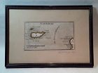
Rare antique Map of Alderney c1691 by Robert Morden with watercolor . Small scale map in nice condition framed and matted c19303s. Overall 9.75 by 6.5" map 5.25" by 3"
Jon Berg Fine Art and More
$195.00
$195.00
Early map titled "A Description of the Land of Goshen and Moses passage through the desert", 1614, by the English cartographer William Hole. Hole was active in cartography from about 1601 to about 1624. The map measures 10 3/4" by 14" inside the present mats (not examined out of the frame but would be happy to do so upon request). This is an uncommon map with a compass rose at lower right and cartouches at upper portion, the cartographer's name at lower left edge. There is probably much late...
All Items : Traditional Collectibles : Ephemera : Photographs : Places : Pre 1900
item #735976
(stock #SK081)
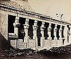
Original Albumen print mounted on coeval cardboard showing Philae - temple of Isis, eastern view of the birth house. Condition: Good, cardboard cut. Dimension: Photo 19 x 22,6 cm., cardboard 20,5 x 24,3 cm.

Alan Kessler Gallery
$200.00
$200.00
Copyright 1907 by Geo. B. Cornish, Arkansas City, Kans. Slightly rounded corners.
Jon Berg Fine Art and More
$200.00
$200.00
Map of the South American continent, titled "Amerique Meridionale", by Felix Delamarche, 1822. The map is on old type laid paper, and measures 12 3/4" by 16 3/4". There is a distinct plate mark and a central fold. The borders of Brazil, Peru, Chile, Patagonia and French Guyana are colored in green, yellow and blue. I do not know if the map is laid down, not having opened it up, but would be happy to do so upon request. There are seven separate dark stains, all except for one in the margins,...
All Items : Traditional Collectibles : Ephemera : Photographs : Special Interest : Pre 1930
item #1460332
Jon Berg Fine Art and More
$200.00
$200.00
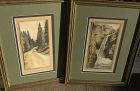
A framed PAIR of hand-colored vintage early 20th century photographs of the scenic Pikes Peak area of Colorado, one titled in pencil in margin "Rainbow Falls Manitou, Colo." and the other "A Glimpse of Pikes Peak--Colo.", both pencil signed "Photo-Craft" at lower right margin. Measurements are 9 1/2" by 4 3/4" (photos) and 17 1/2" by 13 1/2" in identical gold frames with green double mat. There is a bit of brownish discoloration in the margin of the waterfall image, as shown. A date of circa ...

Jon Berg Fine Art and More
$200.00
$200.00
An original copper plate engraved map, with hand coloring of country outlines, and also in the cartouche, titled there, at lower left, "A Map of Turky, Arabia and Persia", the first edition by Georges de l'Isle in 1701, this being the somewhat later revised 1721 edition by noted cartographer of the day John Senex (1678-ca. 1740). This map, 19" by 23" (22 1/2" by 26 1/2" as framed) was considered to be the first modern map of the Arabian Peninsula before the middle of the 18th century. The geog...
All Items : Traditional Collectibles : Ephemera : Photographs : Places : Pre 1900
item #740837
(stock #SK077)

Original Albumen print mounted on coeval cardboard showing the Greek temple in Paestum, Italy. Condition: Photo with some small stains, cardboard cut. Dimension: Photo 20,6 x 25,6 cm., cardboard 28,6 x 33,1 cm.
