
FEATURED ITEMS
 | 1937 CANADA Silver One Dollar Coin VF+ |
 | The World of Atget ~ Berenice Abbott~ 1964 |
SALE PRICED
 | Young People's Illustrated Bible History...1879 Engravings+Maps |
 |
| 23 Vintage Photographs "Folk Art in Orissa, India" by Dorothy Norman |
Items above include suggestions and sponsored listings. |

Jon Berg Fine Art and More
$225.00
$225.00
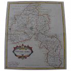
Antique early map of central England's Oxfordshire county, by cartographer Robert Morden, originally published in 1695. This map is nicely hand colored. It measures 17" by 15" inside the green mat and 24" by 22" framed (no glass). The mat was seemingly permanently affixed over the margins of the map by the framer, but the central portion of the map does not appear to be laid down as there is play to the surface. There is central horizontal crease and slight handling creases in the field...
Jon Berg Fine Art and More
$225.00
$225.00
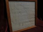
For the collector of things relating to the history of the state of Missouri, here is an early survey map drawn completely by hand, titled at top "Estate of Jos. Hickam decd. in 1848...", signed at bottom right by the surveyor, one W.W. Trent of Cooper County. Cooper County is near today's I-70, roughly between Boonville, Missouri and Columbia, Missouri...

Fiona Kenny Antiques
$225.00
$225.00
A motorcycle & sidecar tintype circa 1905 with a historic view. This scarce, very early photograph is on a late tintype (photo on treated metal blank) and this 2-3/8 x 1-5/8" (view area) image consists of a young motorcycle rider astride the bike with a rather concerned-looking grandma in the sidecar. Three other ladies stand behind her, and there is an Edmonson's Red Seal Toffee pail in the middle of the road (road hazards were a little different in those days...)...
Jon Berg Fine Art and More
$225.00
$225.00
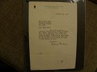
A typed letter on the stationery of famous American novelist, playwright, short story writer EDNA FERBER (1885-1968), dated February 13, 1937, signed in ink by Ferber. It is addressed to a Miss Janet Cohn of Park Avenue, New York, and reads: "Dear Miss Cohn/You wrote to me about a possible dramatization of THE AFTERNOON OF A FAUN. Has the young author ever done any playwriting, or is this his first attempt? Would you be good enough to let me know a little more about him...
All Items : Traditional Collectibles : Ephemera : Photographs : Places : Pre 1900
item #740837
(stock #SK077)

Original Albumen print mounted on coeval cardboard showing the Greek temple in Paestum, Italy. Condition: Photo with some small stains, cardboard cut. Dimension: Photo 20,6 x 25,6 cm., cardboard 28,6 x 33,1 cm.
All Items : Traditional Collectibles : Ephemera : Photographs : Places : Pre 1900
item #735986
(stock #SK082)
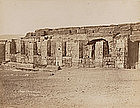
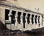
Original Albumen print mounted on coeval cardboard showing the temple of Sethos I. The pillared portico preceding the outer hypostyle. Caption in French: Temple d'Osiris à Abydos, Hte Egypte. Photographer: Pascal Sébah, Turkey, active during the period of 1856 - 1900. Condition: Photo slightly faded. Cardboard slightly stained, corners with small losses, edges slightly toned. Dimension: Photo 19,6 x 25,1 cm., cardboard 29,7 x 40,6 cm.

Alan Kessler Gallery
$200.00
$200.00
Copyright 1907 by Geo. B. Cornish, Arkansas City, Kans. Slightly rounded corners.

Jon Berg Fine Art and More
$200.00
$200.00
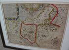
An original copper plate engraved map, with hand coloring of country outlines, and also in the cartouche, titled there, at lower left, "A Map of Turky, Arabia and Persia", the first edition by Georges de l'Isle in 1701, this being the somewhat later revised 1721 edition by noted cartographer of the day John Senex (1678-ca. 1740). This map, 19" by 23" (22 1/2" by 26 1/2" as framed) was considered to be the first modern map of the Arabian Peninsula before the middle of the 18th century...
All Items : Traditional Collectibles : Ephemera : Photographs : Special Interest : Pre 1930
item #1460332
Jon Berg Fine Art and More
$200.00
$200.00
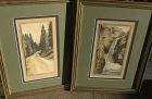
A framed PAIR of hand-colored vintage early 20th century photographs of the scenic Pikes Peak area of Colorado, one titled in pencil in margin "Rainbow Falls Manitou, Colo." and the other "A Glimpse of Pikes Peak--Colo.", both pencil signed "Photo-Craft" at lower right margin. Measurements are 9 1/2" by 4 3/4" (photos) and 17 1/2" by 13 1/2" in identical gold frames with green double mat. There is a bit of brownish discoloration in the margin of the waterfall image, as shown...
All Items : Traditional Collectibles : Ephemera : Photographs : Places : Pre 1900
item #735976
(stock #SK081)
Original Albumen print mounted on coeval cardboard showing Philae - temple of Isis, eastern view of the birth house. Condition: Good, cardboard cut. Dimension: Photo 19 x 22,6 cm., cardboard 20,5 x 24,3 cm.
Jon Berg Fine Art and More
$200.00
$200.00
Map of the South American continent, titled "Amerique Meridionale", by Felix Delamarche, 1822. The map is on old type laid paper, and measures 12 3/4" by 16 3/4". There is a distinct plate mark and a central fold. The borders of Brazil, Peru, Chile, Patagonia and French Guyana are colored in green, yellow and blue. I do not know if the map is laid down, not having opened it up, but would be happy to do so upon request...
Jon Berg Fine Art and More
$195.00
$195.00
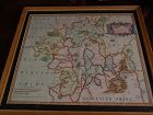
This is a very detailed map of Worcestershire in western England, first engraved by noted London map maker Robert Morden in 1695 for Camden's Britannia, and issued in several later editions in the early years of the 18th century. The map measures 14 1/4" by 16 5/8" inside the mat (17" by 19" as framed). Like most of its type it has been hand colored at a later date...
what pdx
$195.00
$195.00
Rare antique Map of Alderney c1691 by Robert Morden with watercolor . Small scale map in nice condition framed and matted c19303s. Overall 9.75 by 6.5" map 5.25" by 3"
Jon Berg Fine Art and More
$195.00
$195.00
Early map titled "A Description of the Land of Goshen and Moses passage through the desert", 1614, by the English cartographer William Hole. Hole was active in cartography from about 1601 to about 1624. The map measures 10 3/4" by 14" inside the present mats (not examined out of the frame but would be happy to do so upon request). This is an uncommon map with a compass rose at lower right and cartouches at upper portion, the cartographer's name at lower left edge...
All Items : Traditional Collectibles : Ephemera : Photographs : Pre 1900
item #1376134
(stock #TBD00244)
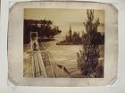
An oversize albumen photograph of a carriage on a narrow bridge with the rising spray from Niagara Falls visible in the distance. I am reasonably confident that this a bridge connecting Goat Island to the river bank on the American side or possibly a bridge connecting Goat Island to one of the Three Sisters. It was likely taken and printed by George Barker, though no title or name is on either the front of the image or on the back of the mount...
David Anthony
$175.00
$175.00
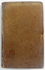
Hardcover...
Jon Berg Fine Art and More
$175.00
$175.00
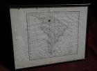
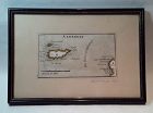
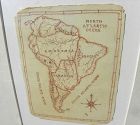
A charming completely hand-drawn map of the South American continent, likely created by a school child at a time when geography was taught to youngsters, measuring 8 1/2" by 6 1/2" (19" by 15 1/2" in black strip modern framing). The age looks to be 19th century. The creator used a red-brown ink, and pencil underlying in some places. Note the cartouche at lower right, and the quaint term "Amazonia" and "Brasil" spelling. The map has been mounted in recent times. The mat seems to have been used...
Jon Berg Fine Art and More
$175.00
$175.00
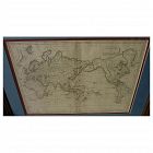
Early 19th century map of the world, in Mercator projection, the Pacific Ocean at center, titled at upper right "Mappemonde sur la Projection de Mercator", measuring 10" by 14 1/2" inside the double mats, and 16" by 21" as nicely framed. The map might date to about the 1820's. The United States is shown as "Etats Unis". There are numerous picturesque early geographic names like "Is. Sandwich/Owhyhee", "Othahiti", "Nouvelle Hollande" for Australia, The map is printed on old style paper. Othe...
